More than one hundred dams have been built by the Reclamations Bureau of the United States Government in the Western States. These structures have irrigated and made productive millions of acres of barren waste
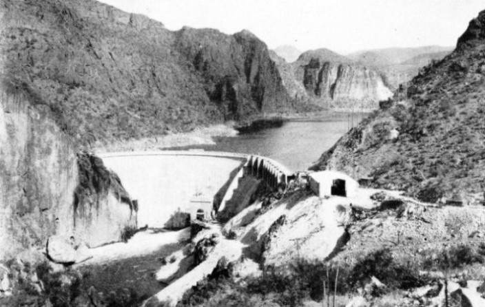
ELEPHANT BUTTE DAM was built across the Rio Grande, New Mexico, in 1915, and was at that time the largest structure of its kind. The dam is 1,200 feet long, with a maximum height of 300 feet. The reservoir created by the dam is forty-five miles long and serves to reclaim nearly 200,000 acres of fertile land from the desert.
TO have built more than a hundred dams, among them the greatest structures of their kind, and to have carried out this work in uninhabited desert country, far from the centres of civilization, is a feat worthy of recognition. Such is the claim of the Reclamations Bureau of the United States Government, first organized in 1902.
This work of reclaiming the desert lands of America still goes on. On an average the Bureau spends annually more than £5,000,000 of its own funds on construction work alone. In addition, there are also the special grants made by the Government to enable important Federal undertakings to be carried out. The money which the Bureau spends comes from various sources, chiefly from repayments made by water-users, from the sale of land, electric power and light, and from oil and other mineral rights. That this work of reclaiming desert land is a profitable proposition is proved when it is stated that in 1936 some 3,000,000 acres of land under the Bureau’s control raised irrigated crops of a value of £21,400,000. Before the water was turned upon this land it was virtually valueless.
With little exception, the whole of the vast territory lying between the western boundary of the Mississippi Valley and the Pacific Coast is a waterless region. Although this territory is alluded to as desert, it is not exactly a sandy or stony waste devoid of all life. It is rather a land of little rain, few streams, dry soil, high temperature and almost unbroken sunshine. Once water is turned upon it this useless and barren land at once becomes fertile. In ordinary circumstances a 40-acres farm is regarded as about adequate for the maintenance of a family of five. On the newly irrigated farms of the desert it has been shown that a 5-acres plot will easily support such a family.
Already some 20,000,000 acres of waste land have been made suitable for cultivation through Government and private enterprise, but engineers hope eventually to double this area. The irrigation engineer is creating a great new country in the West, capable of supporting millions of people in comfort and prosperity.
Upon its hundred dams and other water conservation schemes the Bureau had spent £52,400,000 by 1937. This did not include the £22,400,000 which the Bureau spent on the Boulder Dam, or what is being spent in connexion with the Grand Coulee Dam, these being special Federal undertakings. The Grand Coulee Dam, on the Columbia River, is designed as the greatest of all dams and the largest concrete structure ever built.
Apart from the erection dams, whose reservoirs have an aggregate capacity of 30,434,000 cubic yards of water, the engineers of the Bureau had in 1937 dug 18,750 miles of canals, ditches and drains. Supplementary to their main work they had
bored 283 tunnels, built 1,728 miles of road, 156 miles of telephone line, forty-three power plants and 3,878 miles of transmission lines. The work has entailed the excavation of 402,320,000 cubic yards of material, and called for the use of 12,100,000 barrels of cement.
Over the Western States of America the Bureau in 1937 had an army of 6,000 men engaged on no fewer than forty-seven different irrigation projects, many of the undertakings of a colossal character. Among its army of workers are noted engineers, pioneers in modern water conservation. Through long experience and training in the field they have brought the building of dams and waterworks to an exact science.
Daring the past thirty years or so notable progress has been, made in the methods of building dams. The older masonry dams were built of rubble containing from 60 to 70 per cent of stone laid up by hand with mortar and spalls, or chipped stone. The upstream faces were cut stone with comparatively thin, well-pointed joints. The more modern type is of cyclopean concrete containing a far smaller percentage of large stone (25 per cent or less) with the faces of the dam built of concrete laid against forms. In the more recent examples the use of “plums” (see the chapter “Fighting the Drought Menace” describing the construction of the Burrinjuck Dam), or derrick stone, is frequently abandoned altogether, the entire body of the dam consisting of concrete, with the addition of cobble rock to the mix in the more massive portions of the structure.
Similarly, methods of analysis and knowledge of stresses have made great advances. It is necessary for an engineer to know what pressure his retaining walls will be called upon to withstand. Valuable information has been learned in recent years by inserting into the walls of these structures special instruments which have recorded the pressure against them. The pressure against the face of a large dam is tremendous. At one foot below the surface of the water, a large body of water, such as that held in check by the great dams of the world, exerts a pressure of 62½ lb. to the square foot; at ten feet the force is 625 lb., and at a depth of 100 feet no less than 6,250 lb. to the square foot. The higher the dam the greater becomes the pressure.
To obtain a solid foundation and to prevent any possible seepage under the dam, the engineer has to carry out extensive surveys in the river bed. He often finds it necessary to resort to considerable grouting to bind the structure firmly to the solid rock. The river banks, too, need special attention. It may also be necessary to build special weirs and a network of channels, all of which involve careful planning. In these great irrigation projects there are almost innumerable points which the engineer has to study.
One of the more famous structures built by the engineers of the Bureau is the Roosevelt Dam across the Salt River, in Arizona. Its location is some seventy-five miles east of Phoenix, in what was once an almost inaccessible region and the favourite haunt of hostile Indians.
THE WESTERN STATES of America are largely waterless and barren. Irrigation engineers, however, by building numbers of dams across such rivers as the Rio Grande, New Mexico, the Salt River, Arizona, and the Columbia River, Washington, have reclaimed vast regions and made them fit for settlement.
Before the work could be begun it was necessary, because of the remoteness of the site from a railway, to build a first-class wagon road across the desert and through forty miles of wild and rugged mountain country. This road is regarded as one of the most picturesque highways on the American continent. It was built largely by the Apache Indians. Although many of them were noted marauders and cattle thieves and not a few were suspected of murder, the Indians proved good workers.
The road completed, a large camp was established at the entrance to Salt River Canyon and preparations were made for work upon the dam. There being no fuel within thirty miles, power was obtained by harnessing the stream some nineteen miles
above the site of the dam. It was found necessary to build a sluicing tunnel 12 feet wide, 10 feet high and 490 feet long.
It presented, however, many difficulties. A rise of two feet in the river was sufficient to flood both approaches to the tunnel with mud and river debris, and this occurred on three occasions during the progress of the work. Several hot springs were
encountered and the temperature rose to 130 degrees Fahrenheit. This water emitted a steam-like vapour which was almost suffocating. The men worked stripped to the waist, coming out at short intervals for a breath of air. Tunnel and turbines, however, were built and 400 horse-power was generated. This power was used in the building of the dam.
The site of the retaining wall is a narrow gorge cut by the river through a lofty ridge of sandstone, which supplied the necessary material for the dam. The engineers planned to erect it in three years, but it took nearly five. Much trouble was experienced with floods. The first season’s work consisted of building a large cofferdam and digging a deep channel to divert the stream while the foundations were being secured. Unexpected floods, however, of exceptional severity broke up the cofferdam, despite herculean efforts to save it, and carried it completely away. The dam is of rubble masonry with coursed rubble faces, laid in Portland cement mortar. It is 158 feet wide at the base, tapering to 16 feet at the top.
It has a length of 235 feet at the base and is 280 feet high. The length of the dam at its crest, including spillways, is 1,125 feet. The dam is of the arch-gravity type. There are two spillways, one at either end of the dam, with a normal capacity of 113,000 cubic feet a second and a maximum capacity of 150,000 cubic feet a second. Each spillway is 200 feet long, with a crest elevation of 220 feet. The top of the dam forms a roadway, twenty feet above the crests of the spillways, these being spanned by reinforced concrete bridges. The quantity of masonry used in the dam was about 340,000 cubic yards.
TWENTY-FIVE OUTLETS are provided in the Arrowrock Dam, on the Boise River, Idaho. The dam, which contains more than 600,000 cubic yards of concrete, is 1,100 feet long and 353 feet high, being 223 feet thick at the base. The capacity of the reservoir is 244,330 acre feet, or nearly 80,000 million gallons.
The dam has formed a lake 25½ square miles in area, containing 500,000,000,000 gallons of water. From this reservoir water is carried by canals and smaller channels over a tract of land 250,000 acres in extent. A power plant was also built at the dam, with a capacity of 21,000 horse-power.
Since the erection of the Roosevelt Dam many others have been built in Arizona. This State is almost as large as Italy, being some 114,000 square miles in area, but with a population of only about 435,000. This territory has the greatest area of desert of all the Western States of America with the largest sahuaro (giant cacti forest) in the world.
On the Salt and Agua Rivers, and the Rio Verde, in the centre of Arizona Desert, no fewer than seven large dams were built in 1925-37. The last of these was the Horse Mesa Dam, just below the Roosevelt Dam, on the Salt River. It is a masonry structure 311 feet high, and has formed a lake twenty square miles in extent, thus retaining almost as great an amount of water as the Roosevelt Dam.
Below the Horse Mesa Dam there are three other great barriers — the Mormon Flat, Stewart Mountain and the Granite Reef Dams. They are all on the Salt River, and thus this stream, for a distance of eighty miles, has been converted into a series of great artificial lakes.
Some of these structures were built by the Salt River Valley Water Users’ Association from plans supplied by the Bureau. A recent Government undertaking in Arizona was the Coolidge Dam, on the Gila River. It is a fine masonry structure 250 feet high, which has created a reservoir over thirty square miles in extent. This dam was built for a double purpose — to control the flood waters of the Gila River and to provide water for irrigating 120,000 acres of land near the town of Florence. It was necessary to remove one entire town, scores of farmhouses and a section of the Southern Pacific Railroad.
91 Feet Below the River Bed
Idaho has been the scene of some interesting triumphs on the part of the irrigating engineer. This State is rugged and mountainous and overlaid with vast lava sheets, as are also the adjoining States of Oregon, Washington and Wyoming. The valleys, provided water is available, are wonderfully fertile. Before work could be started on the Arrowrock Dam on the Boise River, Idaho, the engineers sank fifty-nine drill holes over the proposed foundation area and along the spillway, besides several test pits and tunnels to determine the true nature of the river bed. This being of loose volcanic rock, it was found necessary to go down to a depth of 91 feet below the bed of the stream to reach solid granite. Then came the building of a diversion channel, 500 feet long, round the site through a cliff to provide an outlet for the river until work was far enough advanced to permit the storage of water.
The dam, with a further five feet recently added, is 353 feet high, and 223 feet thick at the base, tapering to 16 feet at the top. It is 1,100 feet long, and contains over 600,000 cubic yards of concrete. The crest carries a roadway 16 feet wide. The structure is of the gravity type, and is built on a curve with a radius of 662 feet. There are twenty-five outlets through the dam, which vary in diameter from 60 in. to 72 in., and are controlled by sliding gates. The spillway is of somewhat unusual design. It is fitted with movable crest gates which permit the storage of water six feet higher than the fixed crest. These gates drop automatically in the event of a flood, to give full capacity to the spillway when needed. The gates rise automatically again when the flood has passed. The capacity of the spillway is 40,000 feet a second.
A NARROW GORGE IN A SANDSTONE RIDGE is the site of the Roosevelt Dam across the Salt River, Arizona. The roadway, which is carried along the crest of the dam and over the spillway channels by reinforced concrete bridges, was built largely by Apache Indian labour. The dam has formed a lake 25½ square miles in area containing 500,000 million gallons of water.
Above the dam, in the basin of the Boise River, there are 3,000,000,000 feet of good timber; the mills are fourteen miles below. A device is built at one end of the dam to hoist logs of any size or length from the reservoir, carry them over the top and shoot them into the river below. This device has a capacity of 1,000,000 feet a day during the time of the year when the water in the reservoir is within 45 feet or less of the top of the dam. A cable lift picks the logs out of the reservoir and swings them to a platform on top. From here they are carried by a chain through a concrete chute 650 feet long and shot down to the river.
The capacity of the reservoir is 244,330 acre feet, or about 79,600,000,000 gallons. The water needed for irrigation is carried down the channel of the river for twelve miles to a low diversion dam and from there it is distributed over the land through a network of canals and channels. It has transformed about 300,000 acres of barren sagebrush desert into fruitful gardens, orchards and farms. A hydro-electric power plant has also been built in connexion with the dam.
Cableway for Locomotives
Other water conservation projects in Idaho,also in the basin of the Boise River, include a masonry diversion dam on the Black Canyon. This dam is 183 feet high and 1,040 feet long. There are also the Upper and Lower Deer Flat earth-filled storage dams, 4,000 feet and 7,200 feet long respectively. Large areas are also being reclaimed in the neighbourhood of the Snake River.
In building the Elephant Butte Dam, on the Rio Grande in New Mexico, by which 180,000 acres were reclaimed from the desert, the engineers found it difficult to transfer their heavy machinery and plant from one side of the gorge to the other. They decided to convey everything across the river by a suspended cableway, and 20-tons railway engines were carried across in this fashion. At the time the dam was built, in 1915, nothing similar had ever been done.
Elephant Butte Dam could claim at that time to be the largest of these masonry structures. It is 1,200 feet long, with a maximum height of 300 feet. It is 215 feet wide at the base, tapering to 18 feet at the top. The capacity of the reservoir is 2,642,292 acre feet. The reservoir is forty-five miles long and submerges 40,000 acres of land. At the time of its creation it was the largest artificially formed lake in the world.
Building a retaining wall across a narrow gorge is often a more difficult proposition than building a dam across a wide river. Typical examples of earlier gorge dams are the Shoshone and Pathfinder Dams in Wyoming. The Shoshone Dam is on the river of that name, in a gorge 2,000 feet deep and eight miles long. Down through this narrow opening, with its towering, almost perpendicular, granite walls, ran a turbulent, stream, which it was desired to harness for irrigation purposes.
After extensive borings through a deposit of drift 60 feet to 90 feet deep, a site for the dam was selected at the narrowest point of the gorge, where the canyon was only 70 feet wide at the water level. First came the making of a road cut out of the solid rock along the edge of the gorge to the site of the dam. This was followed by the boring of a diversion tunnel to divert the flow of the stream while the foundations were being built. It proved arduous work and there were many setbacks. Unexpected high floods swamped the diversion works and in the early stages of the undertaking the temporary dam built to divert the stream was partly destroyed.
ACROSS THE COLUMBIA RIVER, in the State of Washington, a huge cofferdam was built to divert the flow from part of the site of the Grand Coulee Dam. In the foreground can be seen part of the large camp which houses the engineers working on the dam. The bridge across the river was finally embedded in the concrete of the dam.
The engineers stuck to their task, however, and after five years of arduous labour the dam stood complete. Although it measures 200 feet along the crest, it is only some 70 feet across at its base, being virtually a wedge of concrete fixed in a deep gorge. The height of the dam is 328 feet, and for many years the Shoshone Dam held the record as being the highest of dams. The dam is provided with two outlet tunnels, 10 feet square, and a spillway. The reservoir formed by the retaining wall is ten square miles in extent with an average depth of 75 feet, by which a tract of land 135,000 acres in extent has been made fit for cultivation.
One of the most spectacular water conservation feats carried out by the engineers of the Bureau is that known as the Uncompahgre Project. The Uncompahgre Plateau is a tract of land in south-western Colorado and belonged to the Ute Indians. The Government bought the land from them, moved the Indians elsewhere and opened the district to settlement. The region being attractive and healthy, the land was rapidly taken up. It was all artificially irrigated, however, by the waters of the Uncompahgre River. After a few years this stream suddenly dried up, so that the irrigated area decreased, orchards perished, and thousands of settlers had no option but to abandon their farms and leave the district.
It was clear that no more water could be brought down the Uncompahgre, but running parallel to it a few miles away was the Gunnison River. This stream flows for miles in a gorge more than half a mile deep. How to divert the waters of this gorge into the
valley was the problem. It was apparent that the diversion, if it were possible, could be effected only by a tunnel with one end in the canyon and the other on the Uncompahgre side, driven through the intervening mountain of Varnal Mesa, which is 2,000 feet high.
An Adventurous Voyage
To add to the difficulties this particular portion of the Gunnison Canyon had never been explored. Attempts had been made, it is true, but no man had ever succeeded in passing through the gorge alive. Nothing daunted, two of the Bureau engineers, A. L. Fellows and his assistant, W. W. Torrence, determined to explore the gorge. As no boat could pass through the foaming roaring waters, they resorted to an inflated rubber mattress. Upon this they loaded provisions, instruments and photographic materials. Through the exciting days which followed they took their lives in their hands. Nearly every moment was filled with heartbreaking hardships. Fellows prepared his notes with care, took many photographs and developed the negatives at night. All papers and photographs were carefully wrapped in oilskin and attached to his person. After several days they finally emerged from the canyon by way of the Devil’s Slide, a weary climb requiring several hours for its accomplishment. They escaped with their lives and precious notes and photographs. Their mattress, instruments, cameras and provisions went down with the floods. The notes contained data sufficient to indicate the feasibility of diverting the Gunnison, for it was shown that the elevation of that stream was considerably above that of the Uncompahgre Valley.
WORK ON THE GRAND COULEE DAM. In the foreground concrete is being poured in the easternmost section or the structure. In the central section, from which the Columbia River was diverted by a cofferdam, bedrock is being laid bare for foundations. In the background can be seen a completed concrete block for the western section of the dam.
The final mapping out of the canyon by another of the Bureau’s engineers, I. W. McConnell, was fully as exciting and dangerous as the exploration work of Fellows. McConnell had to be lowered into the canyon so that he could make a map of it. Then he established precise levels at both ends of the proposed tunnel. Care was necessary to see that the slope of the tunnel was such that it would carry the proper amount of water into the valley. To ensure this, levels had to be run over the mountain to the bottom of the canyon. The work was repeated again and again, and measurements were taken each time until the exact slope required had been determined. The work occupied several weeks and necessitated tramping through rough bush country infested with rattlesnakes.
The next procedure was to build a 16-miles road to the canyon, and to establish camps and workshops. This finished, work on the tunnel was begun. It proved, however, anything but an easy task. Almost every difficulty ever encountered in tunnel excavation was met with — gas, cave-ins and subterranean springs. Over and over again the men were driven from the works, and on several occasions it looked as if the project would have to be abandoned; but the engineers stuck to their task and at the end of five years had pierced the mountain with a six-miles tunnel through which water is carried to the thirsty valley. By an elaborate system of canals, 150,000 acres of fine land have thus been made productive. In connexion with the Uncompahgre Project is a dam on the Taylor River, thirty-two miles from the Gunnison, to store 106,230 acre feet of water to supplement
the flow of the Gunnison and so to bring another large area under cultivation.
In 1937 the second highest dam in America was the Owyhee Dam, on the river of that name in Oregon. The dam is a massive masonry structure of the arched gravity type, 405 feet high, with a crest length of 840 feet. The capacity of the reservoir is 524,755 cubic yards, destined to bring under cultivation a tract of land 240,000 acres in extent.
Largest Dam in the World
Okeson has two other large irrigation dams, the Cold Springs Dam, an earth and rock-filled structure 98 feet high and 3,800 feet long, with a reservoir capacity of 789,500 cubic yards, and the McKay Dam, built of gravel and concrete paving, 160 feet high, 2,600 feet long, with a reservoir capacity of 2,304,000 cubic yards.
In the adjoining State of Washington is the Grand Coulee Dam, on the Columbia River, some ninety miles west of Spokane. Begun in December 1935, this scheme, when completed, will dwarf even the Boulder Dam. Grand Coulee is the biggest of dams and the greatest of all concrete structures. The purposes of the project include irrigation, power development, river regulation, and to a minor extent flood control and the improvement of navigation. The dam is designed with a height of 550 feet and a length along the crest of 4,200 feet, only 500 feet less than the crest of the Sukkur Barrage, in Sind. It is a far larger structure, however, than its Indian rival. At its base the Grand Coulee Dam has a width of 500 feet, tapering to 30 feet at the top. It will contain more than three times as much concrete as the Boulder Dam, approximately 11,250,000 cubic yards, representing a weight of about 22,500,000 tons.
The spillway, located in the centre of the dam, is designed for a length of 1,650 feet, with a capacity of 1,000,000 cubic feet of water a second. The dam is planned to raise the surface of the river 355 feet and to create a vast reservoir with a surface area of 82,000 acres, or 128 square miles. With a capacity of 10,000,000 acre feet, the reservoir is designed to reclaim 1,200,000 acres of barren and virtually waste land. At either end of the dam will be a power station, and the total output of electrical energy will be 2,700,000 horsepower. This is more than twice the output of the Boulder Dam plant, and six times that of the giant Dnieper Dam in Soviet Russia. The estimated cost of the entire scheme is £75,000,000.
MORMON FLAT DAM is one of the four great barriers built across the Salt River, Arizona, below the Roosevelt Dam. Thus the Salt River, in a distance of eighty miles, has been converted into a series of great lakes, storing water for irrigation in an arid land.
Click here to see the photogravure supplement to this chapter.


 To obtain a solid foundation and to prevent any possible seepage under the dam, the engineer has to carry out extensive surveys in the river bed. He often finds it necessary to resort to considerable grouting to bind the structure firmly to the solid rock. The river banks, too, need special attention. It may also be necessary to build special weirs and a network of channels, all of which involve careful planning. In these great irrigation projects there are almost innumerable points which the engineer has to study.

 After extensive borings through a deposit of drift 60 feet to 90 feet deep, a site for the dam was selected at the narrowest point of the gorge, where the canyon was only 70 feet wide at the water level. First came the making of a road cut out of the solid rock along the edge of the gorge to the site of the dam. This was followed by the boring of a diversion tunnel to divert the flow of the stream while the foundations were being built. It proved arduous work and there were many setbacks. Unexpected high floods swamped the diversion works and in the early stages of the undertaking the temporary dam built to divert the stream was partly destroyed.